
Extraction of Ship Elevations from Sea Bird Observation Cruise
Tracks
using Gridded Satellite Altimetry Elevation Models
This study was carried out by Diversified Scientific Solutions as part of a contract for Environment Canada under the direction of Dr. Patrick O'Hara in colaboration with Dr. Charles Hannah of the Department of Fisheries and Oceans
Background
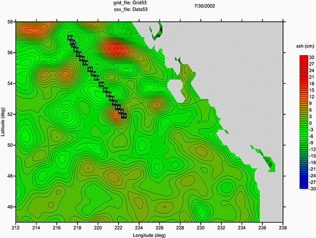
The Colorado Center for Astrodynamics Research (CCAR) has developed daily sea surface height grids using multiple satellite altimeter sensors. These grids clearly define mesoscale eddies which are considered to be important vectors that deliver rich coastal water nutrients to the open ocean. Such nutrients play an important role in supplying a source of vital energy to the water column as well as pelagic birds. Since the mid 1980s, a large database of ship transects have criss-crossed the North Pacific collecting data of bird observations and plankton sampling. Ship elevations were extracted from the available altimeter grids for each cruise date. In this study, 1120 days of ship observations were examined spanning the years 1992-2015. The positions of each sampling location for this time period has been summarized in the plot below.
 (Click on plot to expand)
This work contributes to an integrated study linking DFO’s oceanography work with Environment and Climate Change Canada’s work on seabird foraging ecology.
.
animations of altimetry grids with cruise track elevations posted as daily overlays.
1993 Cruise Track CSV Data: Animation
1994 Cruise Track CSV Data: Animation
1995 Cruise Track CSV Data: Animation
1996 Cruise Track CSV Data: Animation
1997 Cruise Track CSV Data: Animation
1998 Cruise Track CSV Data: Animation
1999 Cruise Track CSV Data: Animation
2000 Cruise Track CSV Data: Animation
2001 Cruise Track CSV Data: Animation
2002 Cruise Track CSV Data: Animation
2003 Cruise Track CSV Data: Animation
2005 Cruise Track CSV Data: Animation
2006 Cruise Track CSV Data: Animation
2007 Cruise Track CSV Data: Animation
2008 Cruise Track CSV Data: Animation
2009 Cruise Track CSV Data: Animation
2010 Cruise Track CSV Data: Animation
2011 Cruise Track CSV Data: Animation
2012 Cruise Track CSV Data: Animation
2013 Cruise Track CSV Data: Animation
2014 Cruise Track CSV Data: Animation
2015 Cruise Track CSV Data: Animation
